Ellen Murphy Family History
Fermanagh Background
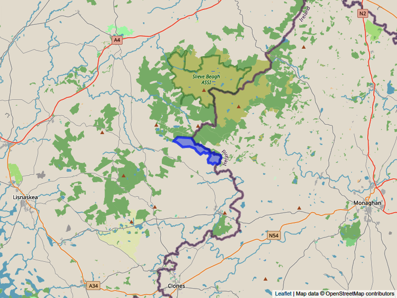
Ellen was born on 19th March 1898 in the townland of Corragunt, East Fermanagh, in the barony of Clankelly, on the border with County Monaghan. Roslea (also commonly spelt Rosslea) is the closest village.
Corragunt on the Fermanagh-Monaghan border
A documentary about Roslea created in 1973 was still available as a podcast on RTÉ in 2024. Find it on RTÉ Radio 1's “Documentary on One” series under the keyword “roslea”.
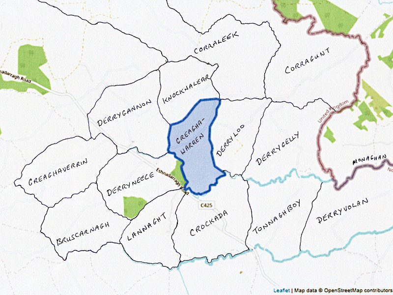
The following map showing the key townlands relevant to the story:
Key townlands around Corragunt
Ellen’s family go back several generations in East Fermanagh. Drawing on the book “The Fermanagh Story”[4], this section provides a brief historical context to this area of Ireland.
Up to the 17th century there was little migration in or out of Fermanagh, so Irish family names are deep rooted. It was a relatively prosperous county, although East Fermanagh has the poorest land in the county. Much of the county was involved in cattle rearing. From 1300 to 1589 the county was dominated by the Maguire clan who ran all sectors of society – both religious and secular. Other significant families retired to manage church lands, and these families were known as Herenach. There was a Murphy Herenach in the townland of Farnamullan, but this is not near Corragunt.
The Maguire leadership left with the flight of the Earls at the start of the 17th century, after which time the area was targeted for plantation by the English to gain control of the area. Trinity College was granted 10,000 acres in Clankelly Barony, including the Manor of Slatmulrooney which includes the townland of Corragunt. The Manor was managed by the Madden family. Some early maps of the area survive in the TCD library[9]. During the 17th century the English planters intermingled with the Irish population. The area around Corragunt was part of poorer land on the edge of Slieve Beagh mountains. It was common land, using transhumance on a rundale system† of sharing the land usage among the tenants. The Slieve Beagh area is still remote today, although it affords great views over the landscape of the North midlands.
After the Battle of the Boyne (1690), Scottish and English Protestants were brought into Fermanagh as part of the drive to suppress Roman Catholicism. The combination of the plantations and the penal laws, which prevented Roman Catholics from owning property, or taking any roles in society, gradually reduced the indigenous Irish population from relative prosperity to a precarious existence as poor peasants. By 1714 the local tenants were being driven out to the poorer areas of land like Corragunt.
In the 19th century a diet based mainly on potatoes supported large families, and tenant holdings were subdivided each generation. This trend was reversed after the great famine. The population of the barony of Clankelly dropped from 15,424 in 1841 to 10,996 in 1851 due to death and emigration triggered by the famine (1845-1849). After that typical landholding sizes increased as holdings were consolidated. An 1896 report described the land as poor and prone to flooding, with little rent available to the landlord.
In the 1790s both the United Irishmen and the Orange Order set up units in Roslea. After a raid by United Irishmen in Roslea in 1797, three men were hanged and became known as the martyrs of Roslea. This set a strong nationalist theme for the village. Sectarian divisions arose in the area at the time of Catholic emancipation in the early 19th century and remained an issue in subsequent conflicts.
In 1837
the village of Roslea had a monthly fair, a flax mill, a police station and a
courthouse[5].
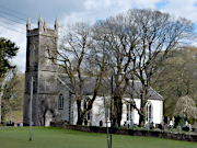
The new Roman Catholic church was described as “a very handsome edifice

 of stone, with a tower and campanile turret, the interior is highly embellished,
the windows are enriched with stained glass and over the altar piece is a fine
painting". This is the church where the births, marriages and deaths of many of the
Murphy family occurred. The church (pictured) is active today, and is very attractive,
located on the edge of the town, set in a beautifully maintained graveyard.
The Report of the Irish Boundary Commission[10] was prepared in 1925, by agreement between the Irish Free State and the British and Northern Ireland Governments. It remained secret until 1968. It is a unique examination of the impact of the 1921 agreement and has lots of information about the border area in the 1920s. Its recommendations were never implemented, as they were leaked and triggered a political crisis, so that they were abandoned. It reported that the Electoral division of Roslea and Eshnadarragh was overwhelmingly Roman Catholic (2024 RC, 245 non-Catholic) and recommended that the village of Roslea and the Catholic area lying immediately to the North of it (including Corragunt) should be transferred to the Free State.
† A system whereby each tenant worked several strips of the land that were not contiguous. ↑


